
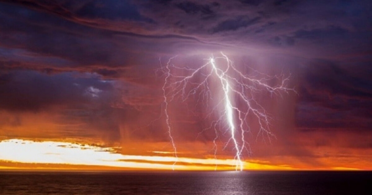
Above: Feature image for the 2019 Australian Weather Calendar – Sunset-lit lightning over Gulf St Vincent, South Australia, 21 January 2018 – Rowland Beardsell
By: Anne Rinaudo
Sometimes by accident, sometimes by design, professional and amateur shutterbugs vie each year for the honour of having their ‘perfect storm’ – or rainbow, cloud or wave – picked as a feature image on the annual Australian weather calendar.
A big seller
The publication is highly sought after and sells out each year. It seems we all love the sight of the extremes of Australian weather. The 2019 calendar is available now and has pictures illustrating each month and a cover image. The photos are dramatic and beautiful – taken in places as far apart as the Northern Territory and Antarctica.
Tough to pick the winners
The Bureau’s CEO and Director of Meteorology Dr. Andrew Johnson said hundreds of photographs are submitted each year, so it is a tough task narrowing them down to just thirteen.
“The calendar’s arrival is always eagerly awaited by weather watchers, while for those behind the camera, having one of your shots included is a real feather in your photographic cap,” Dr Johnson says.
“Since 1983 the Australian Weather Calendar has provided an annual glimpse of the best in Australian photography and a showcase of how nature can be captured and shared.
“The 2019 edition features images from every state and the Northern Territory, plus one from Davis Station in the frozen Antarctic, so it’s geographically as well as visually diverse.”
More than 1.4 million copies of the Australian Weather Calendar have been sold since its inception and this year another 65,000 are set to be added to that total, with orders expected from up to 80 countries.
Cover
This year the honour of gracing the cover went to a photograph by Rowland Beardsell.

Lightning through the lens
Rowland Beardsell was watering his Adelaide garden as the sun was setting, keeping one eye on the sky where a storm had started to develop. When he saw lightning he dropped the hose, grabbed his camera and jumped in the car to drive to nearby Seaford beach. A keen weather photographer who specialises in lightning, he knew that time was of the essence. In fact, as he saw some impressive flashes through the windscreen, he worried he might arrive too late. Luckily there was more to come—including the spectacular sunset lightning featured on the cover of this calendar.
Rowland set up his camera in a hurry, not wanting to miss such a remarkable scene, ‘Normally you don’t get those colours with lightning—it’s quite rare’. Capturing the shot was a technical challenge, partly because the sudden, unpredictable nature of lightning bolts makes framing your photo tricky (or an exercise in luck), and partly due to the dynamic light at that time of the evening. ‘In the moments around sunset the light’s constantly changing and you have to be adjusting your settings as you lose the light.’
Still, if anyone knows their way around weather, it’s Rowland. His lifelong passion for the weather doesn’t just play out in his photography, it’s also a career choice—he works as a full-time weather observer for the Bureau.
The science
Snaking through stormy skies, lightning like that in this photo is one of nature’s most spectacular displays—but it can also be spectacularly dangerous. The high-voltage show is caused by an electrical discharge that occurs within a thunderstorm cloud, between clouds, from clouds to the ground and even from the cloud top into the atmosphere. In the cloud, there are millions of tiny ice crystals and super-cooled water droplets rubbing against each other as they move up and down. This causes a positive charge to develop at the top of the cloud and a negative charge at the bottom. When they discharge, a powerful electric current races from the cloud to the ground and that’s when we see lightning.
January

A moment frozen in time
When it comes to photographing the weather, the sights and experiences in Antarctica are poles apart from mainland Australia. And no one knows this better than photographer and engineer Aaron Stanley, who worked for the Bureau of Meteorology as a Technical Officer at Davis Research Station in 2016. Aaron was responsible for maintaining the automatic weather station network, taking 3-hourly weather observations, and releasing weather balloons while stationed at Davis. He says the whole experience was very surreal but also very challenging. ‘During the winter it would take us about 15 minutes to get dressed because of all the layers you needed for the freezing conditions!’ Aaron says it was the auroras that helped him make it through the bitterly cold and dark winters in Antarctica, with a dazzling display of the Southern Lights almost every night. ‘I would usually set my camera up on a time lapse and leave it out overnight, then change the batteries every 3–4 hours. Aaron says another highlight was capturing this halo and light pillar created by ‘diamond dust’—ground-level cloud composed of tiny ice crystals which is generally only observed in Antarctica and the Artic. It’s these moments photographing rare weather phenomena in extreme locations that keeps the sparkle in his eyes.
The science
When the air is very cold, such as in Antarctica, ice crystals can form in the air close to the ground. This ground-level cloud is called ‘diamond dust’. Interaction between light and the ice crystals can cause different optical phenomena, depending on the shape and orientation of the crystals. Light pillars, like the one at the centre of this photo, form when light reflects off ice crystals. A 22° halo, parts of which are seen here to either side of the pillar, forms when the sun or moon shines through ice crystals: as light passes through the crystals its path is refracted (bent) by 22–50°. No light is refracted at less than 22°, so an observer sees a halo around the light source.
February

Perfectly stationed to witness the storm
It was a work trip that found amateur photographer and coastal and environmental engineer, Elise Lawry, at Legune Station, a remote cattle station in northwest Northern Territory. Conducting site work for consultancy Water Technology on ‘Project Sea Dragon’, a large-scale prawn aquaculture project being developed in northern Australia, Elise was able to witness first-hand the challenges and opportunities of the wet season and effective water management. ‘I’d never been to the Top End before, the scenery was just amazing and there was lots of different changing weather conditions over the 12 months I was working there,’ she says. Elise says as part of her work on Project Sea Dragon the team relied on the Bureau’s cyclone information and other water and climate products. The nearest sealed road to Legune Station is 70 km away, making the most convenient mode of transport helicopter during the wet season—which is where Elise was when she took this photo of an approaching thunderstorm—a moment that has successfully landed her in the Australian Weather Calendar.
The science
In the tropical region of the Top End (where this photo was taken) the seasons are broadly categorised into the ‘dry’ and the ‘wet’—though the Indigenous peoples in the area recognise several more. The wet season begins in October and runs until the end of April each year. As the end of the year approaches, temperatures increase and a shift in the prevailing wind direction brings increased moisture from warm oceans to the north of Australia. Higher temperatures and increased humidity result in the development of thunderstorms, such as this one.
March

Getting high on weather photography
Capturing the weather from great heights is something that’s familiar to Kincumber resident Andy Smith, a professional pilot who manages flying school Central Coast Aero Club out of New South Wales’ Central Coast Airport. ‘I’m lucky that I have an interest in photography and that I fly light aircraft as well, so aerial weather photography has become my thing,’ he says. It was actually in a Cessna aircraft during a flight training session that Andy snapped this double rainbow over Lake Munmorah. ‘I fly every day so see rainbows fairly regularly, but double rainbows are pretty unique,’ he says. Andy says he always takes his camera inflight just in case the sky puts on a show—and the air shows don’t get much more spectacular than this!
The science
Rainbows are formed when sunlight is refracted (bent) and reflected while passing through raindrops. Blue light refracts at a greater angle than red light, resulting in the separation of the colours in the spectrum of white light. Sometimes a dimmer secondary rainbow is visible, as seen in this photo. It is caused by a double reflection of the sunlight inside the raindrop. The colours of the secondary rainbow are inverted. In this photo, green and purple ‘supernumerary’ rainbows are also visible on the inside of the primary bow. These are formed due to the wave-like properties of light.
April

Keeping an eye on the sky
It’s no coincidence that Jenny Feast happened to be in the right place at the right time to capture this dramatic lightning strike over Middleton Beach in Albany, Western Australia. A trained weather observer who has worked at the Bureau of Meteorology since 2009, Jenny’s role often requires her to keep an eye on the sky. A self-confessed ‘weather nerd’, Jenny’s love for weather photography (and surfing!) ensures that even at home she’s constantly checking the Bureau’s synoptic charts and radar imagery. As part of her work she’s first to know what the weather is likely to bring, thanks to the release of weather balloons that track wind speed and direction, temperature, humidity and air pressure. Jenny said she knew there was something special brewing the night she caught this striking shot. ‘There was a cracking rumble after the lightning, and the concrete platform we were standing on shook,’ she recalls. Jenny’s different postings at the Bureau have meant she’s been able to photograph diverse weather all over the country and in remote locations including Willis Island, Cocos Islands, and Antarctica, but it’s the scenic coastline and tight-knit community of Albany that has captured her heart.
The science
Snaking through stormy skies, lightning like that in this photo is one of nature’s most spectacular displays—but it can also be spectacularly dangerous. The high-voltage show is caused by an electrical discharge that occurs within a thunderstorm cloud, between clouds, from clouds to the ground and even from the cloud top into the atmosphere. In the cloud, there are millions of tiny ice crystals and super-cooled water droplets rubbing against each other as they move up and down. This causes a positive charge to develop at the top of the cloud and a negative charge at the bottom. When they discharge, a powerful electric current races from the cloud to the ground and that’s when we see lightning.
May

Hitting the heights of aerial photography
It seemed like a natural progression for Hayden Smith to take his photography business Airtight Aerials to the next level with drone technology. ‘I loved photography and really enjoyed flying drones, so I thought, why not combine the two?’, he says. Hayden has also managed to bring together aerial photography with his other passion—surfing—which is how he came to be at Pyramid Rock in Phillip Island, Victoria, just before sunrise that morning. The plan was to fly the drone until sunrise and then go for a surf, but he says before he knew it a thick cloud of fog came out of nowhere, totally engulfing him. Hayden says he’d never seen anything like it before and couldn’t even see two metres ahead of himself. But, from above, the drone captured something magical—and it’s these unique perspectives that continue to drive Hayden to new heights.
The science
Sea fog, as shown this photo, is formed when warm and moist air passes over a cooler body of water. As the air passes over the surface of the water, it cools, and water vapour in the air condenses to form fog. Breaking waves on the beach release salt particles into the air, which help to form the fog. This kind of fog can be ‘advected’, or pushed, over land by the wind.
June

Going the distance
The saying ‘life’s not a sprint, it’s a marathon’ could also be applied to the art of weather photography, particularly when it comes to Andrew Thomas. A former marathon runner, Andrew continues to apply the same dedication and patience to his photography work—in fact, he rarely ventures beyond 42 km from his home in Ballarat, Victoria, when heading out on his regular photography rounds (42 km being marathon distance, of course!). But, Andrew says there’s no shortage of spectacular scenery within this boundary. ‘I run photography workshops and people are always amazed at what I’ve got to play with so close at hand. We don’t have huge mountains but what I can show you in the Ballarat district is quite extraordinary,’ he says. And looking at this amazing carpet of fog over Mt Buninyong it’s easy to agree. On this particular morning Andrew said there was no fog at all in the Ballarat township, and it wasn’t until he got about 10 km out and started to make his way up the winding road of Mt Buninyong, that he saw fog had blanketed the whole area. He then used a drone to capture the scene from an even greater height. Andrew says he scours the Bureau’s weather forecasts, sometimes by the hour, to see if conditions are favourable for taking his camera out. But, he says it’s the unpredictability of the weather that can really make a winning landscape photo.
The science
Fog forms when water vapour condenses into tiny droplets of liquid water, suspended in the air. This can happen in a variety of circumstances and is most common in autumn and winter under lowering temperatures and calm conditions. The fog in this photo, however, was caused by a moist upslope flow. As the moist wind moves up a slope, the water vapour in the air condenses and a fog is formed. Fog is generally a localised phenomenon and can form in small pockets when the airflow and terrain are suitable.
July

Go where the wind blows
It was a lucky detour that led Margaret Brown to this beautiful scene near the Breakaways in outback South Australia. On a camping trip from Adelaide to Alice Springs, Margaret and her travel companions had been stuck in William Creek for two days due to heavy rains. Instead of heading to Oodnadatta as originally planned, they had to take the road to Coober Pedy, and thankfully the wet weather didn’t follow them. Margaret says while they experienced a variety of weather on their trip to the Red Centre, including dramatic storms and black, threatening clouds, it was these cirrus clouds that caught her eye. She recalls how the clouds danced in the winds against a bright blue sky, contrasting with the red dusty road below. Margaret has had a keen interest in photography since she was a young girl, processing and printing her own films since the age of nine. So, it’s no surprise that she is now the technical editor of Photo Review Australia, a magazine that reviews photographic equipment. ‘Photography is a wonderful way of integrating with the world around you,’ Margaret says. And who knows where it will take her next?
The science
Fine white threads of cloud form a stark contrast to the brilliant blue sky in this photo. The thin and wispy clouds are known as cirrus clouds. They are made of ice crystals and are located high up in the atmosphere. Cirrus clouds often move along in a fast-flowing wind, high above the ground, known as a jet stream. This jet stream crosses Australia from west to east and is part of the general circulation of the atmosphere. It is this fast-flowing wind that gives these clouds their fine stretched-out look.
August

Views from the verandah
The Clarence River in Yamba has long held a special place in Peter O’Donnell’s heart, stemming from when he used to caravan there with his wife and kids more than 30 years ago. These days Peter lives in Yamba and has the luxury of watching the sun set over the Clarence from his back verandah, a view he never gets tired of. ‘There’s a fair amount of scenery around this area,’ he says of the Northern Rivers district, which inspires him to take his camera wherever he goes. Peter first started using a ‘box Brownie’ camera as a kid and has steadily upgraded his equipment over the years. He says it’s so much easier now with digital cameras compared to roll film, but says one of the joys of weather photography is that you’re always learning. And what better place to master the art than right here on his back verandah?
The science
The beautiful colours often seen at sunrise and sunset are formed by the interaction of light from the sun with the Earth’s atmosphere. At sunrise and sunset, the sun is very low on the horizon and the sunlight has a longer path through the atmosphere. As the light travels through the atmosphere, more blue and green light is scattered—leaving only red, orange and yellow hues in the direct beam. Pollution, dust and clouds reflect this light, creating a spectacular display of colour. Alto, or mid-level cloud, such as the cloud shown in this photo, tends to produce the most spectacular sunsets. Cirrus, or high-level cloud can also produce a stunning display as the sun goes down.
September

Head in the clouds
Chris McFerran’s passion for weather photography first began back in the 1990s, after he moved to Queensland’s Southern Downs region. ‘I remember taking photos of cloud formations along the range and while I didn’t understand much about what was actually going on in the atmosphere, I knew the clouds were different,’ he says. ‘They were immense, towering, cumulonimbus thunderstorms and when I developed the first roll of storm-cloud photos, I was instantly hooked!’ This eventually brought forth an intense passion for Chris to document the weather and visual observation was not enough. Chris began honing the craft of photography to capture amazing cloud formations and severe weather phenomena across the Darling Downs. On this particular day, Chris says he watched the ‘tower’ of the cumulonimbus cloud go up over Leslie Dam, and followed it for most of the afternoon before the storm crossed the ranges and this stunning rainbow appeared. This was the pot of gold he’d been waiting for, and to this day it still has him on cloud nine.
The science
Thunderstorms can occur at any time of year, but in Queensland, where this photo was taken, they’re most common from September to March. The frequency of storms during this period is primarily due to the increase in the sun’s energy during the warmer spring and summer months, and extra moisture coming in from the sea, which can combine with seasonal weather patterns that are favourable for storm growth.
October

Call of the wild
It was a call to volunteer in the Tasmanian Wilderness World Heritage Area that led ex-politician and lifelong environmentalist Bob Brown to this angelic sight. Monitoring the wild population of the critically endangered orange-bellied parrot at Melaleuca during an intensive two-week program, Bob was keeping an eye on the sky and quickly grabbed his camera when he spotted this halo. ‘It’s such a magnificent thing to look at, and yet most people don’t even look up,’ he says. Bob says he has always watched the weather with keen interest, and even has a Stevenson screen shelter for meteorological instruments and rain gauge at his bush property in Tasmania. After using his mother’s ‘box Brownie’ camera as a kid and then receiving his first camera in his teens, he has been taking photos of nature ever since. ‘I never use a tripod and set the camera on automatic to make sure I get the shot before it goes,’ Bob says. ‘Some of the most dramatic weather shots are going to be fast-moving—whether it’s a sunbeam sweeping a mountainside, a lightning flash, or a wind squall—and if you’re busy setting up you’re going to miss it.’ In other words, he says, shoot with wild abandon!
The science
Halos, like the one in this photo, form when the sun or moon shines through cirrus or cirrostratus clouds. These high, wispy clouds are made of ice crystals. A halo is formed in a similar way to a rainbow: As light passes through the ice crystals its path is refracted (bent). The angle of refraction varies from 22° to 50°, and no light is refracted at less than 22°. As a result, the observer sees a halo around the light source. The inside edge of the circle appears red because red light is refracted less than light of other colours.
November

Storming home
Growing up in São Paulo before moving to Australia in 2008, Mauricio Bacchi noticed a similarity between the weather patterns in Brazil and those in the place he now calls home on Sydney’s Northern Beaches, Manly. ‘In São Paulo we always had what we used to call “summer rain” in the late afternoon, something not as dramatic as the storm I captured but always wet enough to cool down the summer days a bit,’ he says. ‘I grew up in a huge city, but now living on the beach you can really see the storms develop and I also have the feeling that they are a lot more powerful.’ Mauricio’s passion for photography started with an old Polaroid camera that his grandfather gave him many years ago. He had it stashed away for several years, then one day out of the blue decided to fix it and learn how to use it. He hasn’t stopped shooting since then. In 1999 he began learning the art of old-style photography on black and white film and developing photos in a darkroom. These days he embraces the latest technology, specialising in drone photography and producing huge panoramic shots. And while he travels back to Brazil every now and then to see family, when it comes to photographing amazing weather, Mauricio says there’s no place like home.
The science
The ominous supercell thunderstorm in this photo was generated as a cold front moved across New South Wales. A supercell is a very strong, long-lived type of thunderstorm that can maintain itself for many hours. Supercells are characterised by internal rotation and a continuous large updraught. Their size, longevity and potential for severe weather conditions make them quite dangerous. They are generally the most severe thunderstorms we experience. This one displays spectacular arcus, or shelf clouds. These low, horizontal wedge-shaped clouds attached to the base of the parent cloud are formed by the outflow from the thunderstorm.
December

Music to her ears
Moving to Tasmania from South Australia three years ago, the magical tones of the rugged landscape during winter certainly struck a chord with Leanne Osmond. ‘I have loved weather photography for many years, with a passion for capturing fog and mist back in SA, but after moving to Tasmania I have definitely added capturing snow, frost and ice to that list!’ It was back in 2015 on the road up to the Central Highlands, near the Liffey Falls State Reserve, that Leanne first came across this outcrop of rock dripping with icicles. The following year after experiencing heavy rain and record flooding, followed by a cold snap that produced some snow, she hoped the conditions would produce a similarly spectacular scene. Her hunch proved right, and although it was bone-chillingly cold, Leanne says it was certainly worth the drive. She remembers water constantly dripping down the icicles. Occasionally they melted and snapped off, making beautiful ‘tinkling’ sounds as they fell. Leanne says despite wearing gloves her fingers were aching with the cold, but it’s being able to capture such remarkable sights—and sounds—that make her weather photography all the more noteworthy.
The science
Icicles, like those in this photo, can form when the air temperature is below freezing (0 °C), there is snow or ice around, and the sun is shining. The sunshine warms and melts the surface of the snow or ice a little. This water then runs along until it drips off a branch, leaf or other overhanging object. As the water drips, it refreezes in the very cold air, forming the base of an icicle. The icicle grows as drop after drop of water runs down it and freezes onto it.
Listen: Meteorologist, Grace Legge, from the Bureau of Meteorology’s Extreme Weather Desk, in conversation with Stephen O’Doherty.
Article supplied with thanks to Open House.
About the Author: Anne is the producer of Open House – a weekly three-hour live talkback radio show exploring life, faith and hope from a Christian perspective.